
Railroad Commission of Texas · week of July 6, 2026
New Texas drilling permits, Jul 6–12, 2026
- 194permits issued
- 141horizontal
- 49counties
- 66operators
That week
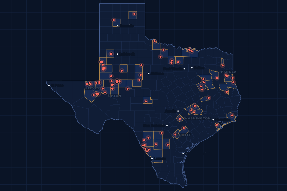
Where the state permitted wells
Counties and operators
Who drills, and where
Each county links to its Well Watch page, with its own map and every permit of the last two years. Each operator links to its page.
By county
- 1Reeves County23
- 2Midland County21
- 3Glasscock County17
- 4Upton County11
- 5Andrews County10
- 6Webb County9
- 7Dimmit County8
- 8Gaines County8
- 9Panola County8
- 10De Witt County7
- 11Washington County6
- 12Fisher County5
- 13Ward County4
- 14Wilbarger County4
- 15Winkler County4
And 34 more counties with fewer, in the list below.
By operator
- 1Pioneer Natural Res. USA, Inc.28
- 2Chevron U. S. A. Inc.11
- 3Cog Operating LLC11
- 4Mewbourne Oil Company8
- 5Devon Energy Production Co, L.P.7
- 6Magnolia Oil & Gas Operating LLC7
- 7VTX Energy Operating, LLC7
- 8Greenlake Energy Operating, LLC6
- 9Caturus Energy, LLC5
- 10Coke Co. Operating5
- 11Burk Royalty Co., Ltd.4
- 12Continental Resources, Inc.4
- 13Diamondback E&P LLC4
- 14Jonah Energy LLC4
- 15OXY USA Inc.4
And 51 more operators with fewer.
Register · July 6–12, 2026
Every permit, newest first
As the state files them: the lease and well, the operator, the kind of permit and the depth. “On the map” opens the county's live map at the well's spot.
Friday, July 1058 permits
- Archer CountyProthro, well 108Newport Operating, LLC · new drill · vertical · 2,000 ftPermit 0917016 · API 42-009-43439On the map
- Coke CountyMariena, well 1Go Opco T LLC · re-entry · vertical · 6,653 ftPermit 0916764 · API 42-081-31355On the map
- Cooke CountyClegg Nw, well 1HOil Capital Operating, LLC · new drill · horizontal · 17,600 ftPermit 0916997 · API 42-097-34867On the map
- Crane CountySyndicate Fee 'A', well 4Green Century Exp & Prod, LLC · recompletion · vertical · 4,343 ftPermit 0916955 · API 42-103-32795On the map
- De Witt CountyHeibel A, well 16HDevon Energy Production Co, L.P. · new drill · horizontal · 14,000 ftPermit 0916970 · API 42-123-35816On the map
- De Witt CountyHeibel A, well 15HDevon Energy Production Co, L.P. · new drill · horizontal · 14,000 ftPermit 0916969 · API 42-123-35815On the map
- De Witt CountyHeibel A, well 14HDevon Energy Production Co, L.P. · new drill · horizontal · 14,000 ftPermit 0916968 · API 42-123-35814On the map
- De Witt CountyHeibel A, well 13HDevon Energy Production Co, L.P. · new drill · horizontal · 14,000 ftPermit 0916967 · API 42-123-35813On the map
- De Witt CountyHeibel A, well 12HDevon Energy Production Co, L.P. · new drill · horizontal · 14,000 ftPermit 0916966 · API 42-123-35812On the map
- De Witt CountyHeibel A, well 11HDevon Energy Production Co, L.P. · new drill · horizontal · 14,000 ftPermit 0916965 · API 42-123-35811On the map
- De Witt CountyHeibel A, well 10HDevon Energy Production Co, L.P. · new drill · horizontal · 14,000 ftPermit 0916964 · API 42-123-35810On the map
- Dimmit CountyComanche, well 6062HEl Toro Resources LLC · new drill · horizontal · 4,900 ftPermit 0917035 · API 42-127-39211On the map
- Dimmit CountyComanche, well 6061HEl Toro Resources LLC · new drill · horizontal · 4,900 ftPermit 0917034 · API 42-127-39210On the map
- Fisher CountyMary K. Kennedy, well 4Coke Co. Operating · re-entry · vertical · 3,783 ftPermit 0916892 · API 42-151-01775On the map
- Fisher CountyMary K. Kennedy, well 3Coke Co. Operating · re-entry · vertical · 3,787 ftPermit 0916891 · API 42-151-01774On the map
- Fisher CountyMary K. Kennedy, well 2Coke Co. Operating · re-entry · vertical · 3,799 ftPermit 0916886 · API 42-151-01773On the map
- Fisher CountyCassle, H. O., well 9Coke Co. Operating · re-entry · vertical · 3,797 ftPermit 0916876 · API 42-151-01758On the map
- Fisher CountyCassle, H. O., well 5Coke Co. Operating · re-entry · vertical · 3,766 ftPermit 0916875 · API 42-151-01754On the map
- Freestone CountyBest SWD, well 4Hilcorp Energy Company · recompletion · vertical · 14,410 ftPermit 0917024 · API 42-161-31744On the map
- Frio CountyBordovsky J S 'A', well 191 ACentral Gulf Petroleum Inc · new drill · vertical · 3,850 ftPermit 0917140 · API 42-163-34431On the map
- Gaines CountySeminole San Andres Unit, well 3115OXY USA Inc. · recompletion · vertical · 6,000 ftPermit 0917030 · API 42-165-31452On the map
- Gaines CountySeminole San Andres Unit, well 3115OXY USA Inc. · recompletion · vertical · 6,000 ftPermit 0917027 · API 42-165-31452On the map
- Gaines CountyMoulton, well 2305HBce-Mach III LLC · new drill · horizontal · 8,300 ftPermit 0916777 · API 42-165-39035On the map
- Hockley CountyStinger, well 1Texland Petroleum, L.P. · new drill · vertical · 6,700 ftPermit 0916996 · API 42-219-37582On the map
- Jack CountyParker, well 2Oakridge Oil and Gas, LP · recompletion · vertical · 5,910 ftPermit 0917102 · API 42-237-39402On the map
- Jack CountyRichards Ranch, well O 4Oakridge Oil and Gas, LP · recompletion · vertical · 2,099 ftPermit 0917084 · API 42-237-40662On the map
- Jack CountyParker, well O 4Oakridge Oil and Gas, LP · new drill · vertical · 3,000 ftPermit 0917001 · API 42-237-40725On the map
- Loving CountyDbm 54-2-21, well 1DSolaris Water Midstream, LLC · recompletion · vertical · 8,200 ftPermit 0917142 · API 42-301-35103On the map
- Madison CountyForrest D State Unit, well 802Empire Texas Operating LLC · recompletion · vertical · 9,740 ftPermit 0916990 · API 42-313-31235On the map
- McMullen CountyHill Creek-Lazy Fork, well 111HCaturus Energy, LLC · new drill · horizontal · 17,500 ftPermit 0917137 · API 42-311-37705On the map
- Menard CountyAlda Davis, well 2Geosurveys, Inc. · recompletion · vertical · 3,018 ftPermit 0916842 · API 42-327-31137On the map
- Midland CountyBob, well 1HMApache Corporation · new drill · horizontal · 12,000 ftPermit 0915930 · API 42-329-48467On the map
- Nacogdoches CountyBear Claw, well 2HRRevenant Energy Operating LLC · new drill · horizontal · 16,500 ftPermit 0916995 · API 42-347-33554On the map
- Nacogdoches CountyBear Claw, well 1HRRevenant Energy Operating LLC · new drill · horizontal · 16,500 ftPermit 0916994 · API 42-347-33553On the map
- Reeves CountyMichelin Man 1/3 D, well F101MPMewbourne Oil Company · new drill · horizontal · 16,650 ftPermit 0916989 · API 42-389-42215On the map
- Reeves CountyMichelin Man 1/3 C, well F101LIMewbourne Oil Company · new drill · horizontal · 16,650 ftPermit 0916988 · API 42-389-42216On the map
- Reeves CountyMichelin Man 1/3 B, well F101EHMewbourne Oil Company · new drill · horizontal · 16,400 ftPermit 0916986 · API 42-389-42214On the map
- Reeves CountyMichelin Man 1/3 A, well F101DAMewbourne Oil Company · new drill · horizontal · 16,400 ftPermit 0916985 · API 42-389-42213On the map
- Reeves CountyGoodrich 12/10 D, well F101MPMewbourne Oil Company · new drill · horizontal · 16,150 ftPermit 0916984 · API 42-389-42212On the map
- Reeves CountyGoodrich 12/10 C, well F101LIMewbourne Oil Company · new drill · horizontal · 16,150 ftPermit 0916983 · API 42-389-42211On the map
- Reeves CountyGoodrich 12/10 B, well F101EHMewbourne Oil Company · new drill · horizontal · 15,900 ftPermit 0916982 · API 42-389-42210On the map
- Reeves CountyGoodrich 12/10 A, well F101DAMewbourne Oil Company · new drill · horizontal · 15,900 ftPermit 0916981 · API 42-389-42209On the map
- Reeves CountyBarracuda Unit 2, well 34HVTX Energy Operating, LLC · new drill · horizontal · 9,882 ftPermit 0914212 · API 42-389-40687On the map
- Smith CountyWilson Vernon 6, well 1Faulconer Energy, LLC · recompletion · vertical · 11,912 ftPermit 0917141 · API 42-423-31680On the map
- Sterling CountyDana Point, well 2HIke Operating, LLC · new drill · horizontal · 8,500 ftPermit 0916959 · API 42-431-33532On the map
- Ward CountyEdwards, Jno. Et Al 'B', well 9Pitts Energy Co. · recompletion · vertical · 5,566 ftPermit 0917025 · API 42-475-34003On the map
- Ward CountyEdwards, Jno. Et Al 'B', well 7Pitts Energy Co. · recompletion · vertical · 5,598 ftPermit 0917004 · API 42-475-33959On the map
- Ward CountyEdwards, Jno. Etal -B-, well 6Pitts Energy Co. · recompletion · vertical · 5,722 ftPermit 0917000 · API 42-475-33958On the map
- Webb CountyTrevino Ranch, well 17HLewis Petro Properties, Inc. · new drill · horizontal · 12,000 ftPermit 0916798 · API 42-479-45673On the map
- Webb CountyTrevino Ranch, well 16HLewis Petro Properties, Inc. · new drill · horizontal · 12,000 ftPermit 0916797 · API 42-479-45672On the map
- Wilbarger CountyCondon, well 6Burk Royalty Co., Ltd. · field transfer · vertical · 8,900 ftPermit 0917018 · API 42-487-33151On the map
- Wilbarger CountyCondon, well 5Burk Royalty Co., Ltd. · field transfer · vertical · 8,900 ftPermit 0917017 · API 42-487-33149On the map
- Winkler CountyBirdie 2803K, well 07HContinental Resources, Inc. · new drill · horizontal · 12,800 ftPermit 0917015 · API 42-495-35219On the map
- Winkler CountyKeystone Holt Unit, well 2503Basin Oil & Gas Operating, LLC · new drill · vertical · 6,200 ftPermit 0916927 · API 42-495-35212On the map
- Yoakum CountyLazy Horse 581-600 D, well 35XHRiley Permian Operating Co, LLC · new drill · horizontal · 7,000 ftPermit 0917147 · API 42-501-37710On the map
- Yoakum CountyCassidy 575-544, well 7XHRiley Permian Operating Co, LLC · new drill · horizontal · 9,000 ftPermit 0916881 · API 42-501-37709On the map
- Yoakum CountyCassidy 575-544, well 6XHRiley Permian Operating Co, LLC · new drill · horizontal · 9,000 ftPermit 0916880 · API 42-501-37708On the map
- Zavala CountyTlapek, well 1RECML Exploration, LLC · recompletion · horizontal · 6,100 ftPermit 0916476 · API 42-507-32726On the map
Thursday, July 930 permits
- Dimmit CountySan Pedro Ranch, well 3712BHJonah Energy LLC · new drill · horizontal · 4,500 ftPermit 0916975 · API 42-127-39209On the map
- Dimmit CountySan Pedro Ranch, well 3711BHJonah Energy LLC · new drill · horizontal · 4,500 ftPermit 0916974 · API 42-127-39208On the map
- Dimmit CountySan Pedro Ranch, well 3710BHJonah Energy LLC · new drill · horizontal · 4,500 ftPermit 0916973 · API 42-127-39207On the map
- Dimmit CountySan Pedro Ranch, well 3709BHJonah Energy LLC · new drill · horizontal · 4,500 ftPermit 0916972 · API 42-127-39206On the map
- Dimmit CountyArsenal B, well 2HCytex South Texas Operating LLC · new drill · horizontal · 9,000 ftPermit 0915208 · API 42-127-39174On the map
- Dimmit CountyArsenal A, well 1HCytex South Texas Operating LLC · new drill · horizontal · 9,000 ftPermit 0915207 · API 42-127-39173On the map
- Gaines CountyWest Seminole Sa Unit, well 0613ROXY USA WTP LP · recompletion · vertical · 6,000 ftPermit 0916931 · API 42-165-38866On the map
- Gaines CountyWhitney, well 6345HBce-Mach III LLC · new drill · horizontal · 10,000 ftPermit 0916775 · API 42-165-39034On the map
- Glasscock CountySquints, well 2HBlack Swan Opco, LLC · new drill · horizontal · 10,500 ftPermit 0916837 · API 42-173-39587On the map
- Glasscock CountyHurt-Brunson 32P, well 16HPioneer Natural Res. USA, Inc. · new drill · horizontal · 10,055 ftPermit 0916099 · API 42-173-39580On the map
- Glasscock CountyHurt-Brunson 32K, well 11HPioneer Natural Res. USA, Inc. · new drill · horizontal · 10,055 ftPermit 0916094 · API 42-173-39575On the map
- Midland CountyNobles Red, well 3004BLContinental Resources, Inc. · new drill · horizontal · 12,150 ftPermit 0916665 · API 42-329-48481On the map
- Midland CountyNobles Red, well 3003BLContinental Resources, Inc. · new drill · horizontal · 12,150 ftPermit 0916664 · API 42-329-48480On the map
- Midland CountyNobles Red, well 3002BLContinental Resources, Inc. · new drill · horizontal · 12,150 ftPermit 0916659 · API 42-329-48479On the map
- Midland CountyCountry Mac A7, well 703MHCog Operating LLC · new drill · horizontal · 10,000 ftPermit 0915569 · API 42-329-48366On the map
- Panola CountyHill Cv C (Aw), well 3HSabine Energy Inc. · new drill · horizontal · 12,000 ftPermit 0916952 · API 42-365-39045On the map
- Reeves CountyWilkinson SWD, well 2NGL Water Solutions Permian, LLC · new drill · vertical · 6,200 ftPermit 0916999 · API 42-389-42208On the map
- Reeves CountyWilkinson SWD, well 1NGL Water Solutions Permian, LLC · new drill · vertical · 6,200 ftPermit 0916998 · API 42-389-42207On the map
- Roberts CountyMcmordie, well 509Texakoma E & P, LLC · new drill · vertical · 10,200 ftPermit 0916599 · API 42-393-32794On the map
- Shelby CountyHarvco, well 8Select Water Solutions, LLC · new drill · vertical · 6,140 ftPermit 0917010 · API 42-419-31944On the map
- Sterling CountySan Marino, well 1HIke Operating, LLC · new drill · horizontal · 8,500 ftPermit 0916958 · API 42-431-33531On the map
- Washington CountyBig Al Eleven, well H 11BEMagnolia Oil & Gas Operating LLC · new drill · horizontal · 12,000 ftPermit 0916901 · API 42-477-31346On the map
- Washington CountyBig Al Nine, well H 09BEMagnolia Oil & Gas Operating LLC · new drill · horizontal · 12,000 ftPermit 0916900 · API 42-477-31345On the map
- Washington CountyBig Al Seven, well H 07BEMagnolia Oil & Gas Operating LLC · new drill · horizontal · 12,000 ftPermit 0916899 · API 42-477-31344On the map
- Washington CountyMeans 'C', well H 05BEMagnolia Oil & Gas Operating LLC · new drill · horizontal · 12,000 ftPermit 0916897 · API 42-477-31343On the map
- Washington CountyMeans 'C', well H 03BEMagnolia Oil & Gas Operating LLC · new drill · horizontal · 12,000 ftPermit 0916896 · API 42-477-31342On the map
- Webb CountyGalvan Ranch, well B929HCaturus Energy, LLC · new drill · horizontal · 17,500 ftPermit 0916963 · API 42-479-45671On the map
- Webb CountyGalvan Ranch, well B927HCaturus Energy, LLC · new drill · horizontal · 17,500 ftPermit 0916962 · API 42-479-45670On the map
- Webb CountyGalvan Ranch, well B925HCaturus Energy, LLC · new drill · horizontal · 17,500 ftPermit 0916961 · API 42-479-45669On the map
- Webb CountyGalvan Ranch, well B923HCaturus Energy, LLC · new drill · horizontal · 17,500 ftPermit 0916960 · API 42-479-45668On the map
Wednesday, July 842 permits
- Anderson CountyEdens-Bowyer (Aw), well 1HPerformance Operating Partners, · new drill · horizontal · 11,300 ftPermit 0916200 · API 42-001-32873On the map
- Andrews CountyMabee Dda A62, well 207LHCog Operating LLC · new drill · horizontal · 12,000 ftPermit 0916909 · API 42-003-49373On the map
- Andrews CountyMabee Dda A56, well 204AHCog Operating LLC · new drill · horizontal · 12,000 ftPermit 0916884 · API 42-003-49367On the map
- Gaines CountyWest Seminole Sa Unit, well 0613ROXY USA WTP LP · recompletion · vertical · 6,000 ftPermit 0916930 · API 42-165-38866On the map
- Gaines CountySeminole San Andres Unit, well 2316OXY USA Inc. · recompletion · vertical · 5,800 ftPermit 0916929 · API 42-165-32753On the map
- Gaines CountySeminole San Andres Unit, well 2316OXY USA Inc. · recompletion · vertical · 5,800 ftPermit 0916928 · API 42-165-32753On the map
- Glasscock CountyHurt-Brunson 32O, well 15HPioneer Natural Res. USA, Inc. · new drill · horizontal · 10,055 ftPermit 0916098 · API 42-173-39579On the map
- Glasscock CountyHurt-Brunson 32N, well 14HPioneer Natural Res. USA, Inc. · new drill · horizontal · 10,055 ftPermit 0916097 · API 42-173-39578On the map
- Glasscock CountyHurt-Brunson 32M, well 13HPioneer Natural Res. USA, Inc. · new drill · horizontal · 10,055 ftPermit 0916096 · API 42-173-39577On the map
- Glasscock CountyHurt-Brunson 32L, well 12HPioneer Natural Res. USA, Inc. · new drill · horizontal · 10,055 ftPermit 0916095 · API 42-173-39576On the map
- Glasscock CountyHurt-Brunson 32J, well 10HPioneer Natural Res. USA, Inc. · new drill · horizontal · 10,055 ftPermit 0916093 · API 42-173-39574On the map
- Glasscock CountyHurt-Brunson 32I, well 9HPioneer Natural Res. USA, Inc. · new drill · horizontal · 10,055 ftPermit 0916092 · API 42-173-39573On the map
- Glasscock CountyHurt-Brunson 32H, well 8HPioneer Natural Res. USA, Inc. · new drill · horizontal · 10,055 ftPermit 0916091 · API 42-173-39572On the map
- Glasscock CountyHurt-Brunson 32G, well 7HPioneer Natural Res. USA, Inc. · new drill · horizontal · 10,055 ftPermit 0916090 · API 42-173-39571On the map
- Glasscock CountyHurt-Brunson 32F, well 6HPioneer Natural Res. USA, Inc. · new drill · horizontal · 10,055 ftPermit 0916089 · API 42-173-39570On the map
- Glasscock CountyHurt-Brunson 32E, well 5HPioneer Natural Res. USA, Inc. · new drill · horizontal · 10,055 ftPermit 0916088 · API 42-173-39569On the map
- Glasscock CountyHurt-Brunson 32D, well 4HPioneer Natural Res. USA, Inc. · new drill · horizontal · 10,055 ftPermit 0916087 · API 42-173-39568On the map
- Glasscock CountyHurt-Brunson 32C, well 3HPioneer Natural Res. USA, Inc. · new drill · horizontal · 10,055 ftPermit 0916086 · API 42-173-39567On the map
- Glasscock CountyHurt-Brunson 32B, well 2HPioneer Natural Res. USA, Inc. · new drill · horizontal · 10,055 ftPermit 0916085 · API 42-173-39566On the map
- Glasscock CountyHurt-Brunson 32A, well 1HPioneer Natural Res. USA, Inc. · new drill · horizontal · 10,055 ftPermit 0916084 · API 42-173-39565On the map
- Grayson CountyMax, well 1Atoka Energy LLC · new drill · vertical · 10,000 ftPermit 0916908 · API 42-181-31654On the map
- Henderson CountyMalakoff South (Bacon Lime) Unit, well 26Cameron Exploration, Inc. · new drill · vertical · 7,600 ftPermit 0916771 · API 42-213-31125On the map
- Hockley CountyFela, well 1CHet Levelland, LLC · new drill · vertical · 11,000 ftPermit 0916946 · API 42-219-37581On the map
- La Salle CountySopwith Camel D, well 4HVerdun Oil Ef II LLC · new drill · horizontal · 9,900 ftPermit 0916954 · API 42-283-37937On the map
- La Salle CountySopwith Camel C, well 3HVerdun Oil Ef II LLC · new drill · horizontal · 9,900 ftPermit 0916953 · API 42-283-37936On the map
- Lee CountyBuck Travis Two, well H 02BTMagnolia Oil & Gas Operating LLC · new drill · horizontal · 10,000 ftPermit 0916801 · API 42-287-32823On the map
- Nolan CountyJoe Young, well 9RScout Energy Management LLC · recompletion · vertical · 5,900 ftPermit 0916883 · API 42-353-33034On the map
- Panola CountyTerlingua A Hv C, well 3HHR. Lacy Services, Ltd. · new drill · horizontal · 12,000 ftPermit 0916260 · API 42-365-39043On the map
- Panola CountyTerlingua A Hv A, well 1HHR. Lacy Services, Ltd. · new drill · horizontal · 12,000 ftPermit 0916257 · API 42-365-39042On the map
- Potter CountyExell Ranch 'A', well 5401Sunlight Exploration, Inc. · new drill · vertical · 10,500 ftPermit 0916828 · API 42-375-31949On the map
- Reeves CountyStill Tippin A2 Unit, well 4505UGreenlake Energy Operating, LLC · new drill · horizontal · 11,000 ftPermit 0916841 · API 42-389-42205On the map
- Reeves CountyStill Tippin A1 Unit, well 3805UGreenlake Energy Operating, LLC · new drill · horizontal · 11,000 ftPermit 0916840 · API 42-389-42206On the map
- Upton CountyRwt Katy 9-28 Unit, well 1551WBChevron U. S. A. Inc. · new drill · horizontal · 12,000 ftPermit 0916357 · API 42-461-43687On the map
- Upton CountyRwt Katy 9-28 Unit, well 1519WBChevron U. S. A. Inc. · new drill · horizontal · 12,000 ftPermit 0916335 · API 42-461-43686On the map
- Upton CountyRwt Katy 9-28 Unit, well 1514LSChevron U. S. A. Inc. · new drill · horizontal · 12,000 ftPermit 0916332 · API 42-461-43684On the map
- Washington CountyCrimson Bear, well H 02BEMagnolia Oil & Gas Operating LLC · new drill · horizontal · 12,000 ftPermit 0916882 · API 42-477-31341On the map
- Webb CountyBriscoe B (SA37), well 1499HSM Energy Company · new drill · horizontal · 7,200 ftPermit 0916898 · API 42-479-45667On the map
- Webb CountyBriscoe B (SA36), well 1488HSM Energy Company · new drill · horizontal · 7,200 ftPermit 0916895 · API 42-479-45666On the map
- Webb CountyBriscoe B (SA35), well 1479HSM Energy Company · new drill · horizontal · 7,200 ftPermit 0916894 · API 42-479-45665On the map
- Winkler CountyBaird, W. E., well 1828Basin Oil & Gas Operating, LLC · new drill · vertical · 6,700 ftPermit 0916926 · API 42-495-35214On the map
- Winkler CountyBaird, W. E., well 1218Basin Oil & Gas Operating, LLC · new drill · vertical · 6,700 ftPermit 0916925 · API 42-495-35213On the map
- Wise CountyStevens, well 1HLakota Energy, Ltd. · new drill · horizontal · 7,500 ftPermit 0916903 · API 42-497-38162On the map
Tuesday, July 722 permits
- Andrews CountyMabee Dda A64, well 209MHCog Operating LLC · new drill · horizontal · 12,000 ftPermit 0916911 · API 42-003-49375On the map
- Andrews CountyMabee Dda A61, well 207JHCog Operating LLC · new drill · horizontal · 12,000 ftPermit 0916890 · API 42-003-49372On the map
- Andrews CountyMabee Dda A60, well 206BHCog Operating LLC · new drill · horizontal · 12,000 ftPermit 0916889 · API 42-003-49371On the map
- Andrews CountyMabee Dda A59, well 206MHCog Operating LLC · new drill · horizontal · 12,000 ftPermit 0916888 · API 42-003-49370On the map
- Andrews CountyMabee Dda A58, well 205LHCog Operating LLC · new drill · horizontal · 12,000 ftPermit 0916887 · API 42-003-49369On the map
- Andrews CountyMabee Dda A57, well 204JHCog Operating LLC · new drill · horizontal · 12,000 ftPermit 0916885 · API 42-003-49368On the map
- Andrews CountyMabee Dda A48, well 1008BHCog Operating LLC · new drill · horizontal · 12,000 ftPermit 0916879 · API 42-003-49366On the map
- Andrews CountyMabee Dda A47, well 1008LHCog Operating LLC · new drill · horizontal · 12,000 ftPermit 0916878 · API 42-003-49365On the map
- Caldwell CountyYoung-Clark Unit, well 1HHamilton, Clay · recompletion · horizontal · 2,400 ftPermit 0916843 · API 42-055-35199On the map
- Freestone CountyNorthen Gas Unit, well 14Hilcorp Energy Company · recompletion · vertical · 12,318 ftPermit 0916904 · API 42-161-34063On the map
- Jefferson CountyGolden Triangle Storage, well 10Golden Triangle Storage, LLC · new drill · vertical · 8,500 ftPermit 0916905 · API 42-245-32939On the map
- Loving CountyDbm 55-1-47, well 2DWes Water Holdings LLC · new drill · vertical · 7,200 ftPermit 0916923 · API 42-301-36562On the map
- Midland CountyTurner W39H, well 8HPioneer Natural Res. USA, Inc. · new drill · horizontal · 10,346 ftPermit 0916262 · API 42-329-48453On the map
- Morris CountyHarrahs, well 1HRose City Resources, LLC · new drill · horizontal · 13,000 ftPermit 0915886 · API 42-343-30140On the map
- Panola CountyE13C Regan Ds, well 4HHTGNR Panola LLC · new drill · horizontal · 22,000 ftPermit 0916847 · API 42-365-39041On the map
- Panola CountyE13C Regan Cs, well 3HHTGNR Panola LLC · new drill · horizontal · 22,000 ftPermit 0916846 · API 42-365-39040On the map
- Panola CountyE13C Regan Bn, well 2HHTGNR Panola LLC · new drill · horizontal · 22,000 ftPermit 0916845 · API 42-365-39039On the map
- Panola CountyE13C Regan An, well 1HHTGNR Panola LLC · new drill · horizontal · 22,000 ftPermit 0916844 · API 42-365-39038On the map
- Upton CountyRwt Brazos 9-28 Unit, well 1528LSChevron U. S. A. Inc. · new drill · horizontal · 12,000 ftPermit 0916284 · API 42-461-43672On the map
- Upton CountyRwt Brazos 9-28 Unit, well 1527USChevron U. S. A. Inc. · new drill · horizontal · 12,000 ftPermit 0916283 · API 42-461-43671On the map
- Upton CountyRwt Brazos 9-28 Unit, well 1526WBChevron U. S. A. Inc. · new drill · horizontal · 12,000 ftPermit 0916282 · API 42-461-43670On the map
- Ward CountyEdwards, Jno. Et Al B, well 3Pitts Energy Co. · recompletion · vertical · 7,000 ftPermit 0916700 · API 42-475-33930On the map
Monday, July 642 permits
- Archer CountyMatus, well 9Guidance Oil Developers,inc.(1) · new drill · vertical · 1,500 ftPermit 0916627 · API 42-009-43436On the map
- Borden CountyClayton, A. M. 'E' NCT-2, well 2Yukon Exploration Operating, LLC · recompletion · vertical · 9,779 ftPermit 0916832 · API 42-033-00992On the map
- Burleson CountyFairway B, well 13HAWildfire Energy Operating LLC · new drill · horizontal · 9,000 ftPermit 0916830 · API 42-051-34422On the map
- Burleson CountyFairway A, well 11HAWildfire Energy Operating LLC · new drill · horizontal · 9,000 ftPermit 0916829 · API 42-051-34421On the map
- Cooke CountyCarolyn Collums, well 1Atoka Energy LLC · new drill · vertical · 16,000 ftPermit 0916776 · API 42-097-34774On the map
- Galveston CountyStewart Title, well 1Frio Resources, LLC · recompletion · vertical · 10,548 ftPermit 0916817 · API 42-167-31547On the map
- Karnes CountyJohnson-Forister Usw F, well 1Burlington Resources O & G Co LP · new drill · horizontal · 17,500 ftPermit 0916195 · API 42-255-38411On the map
- Karnes CountyJohn-For-Fly Usw E, well 1Burlington Resources O & G Co LP · new drill · horizontal · 17,500 ftPermit 0916194 · API 42-255-38410On the map
- Midland CountyRivercrest 47-11 H, well 5WBDiamondback E&P LLC · new drill · horizontal · 12,500 ftPermit 0916827 · API 42-329-48478On the map
- Midland CountyRivercrest 47-11 H, well 5LSDiamondback E&P LLC · new drill · horizontal · 12,500 ftPermit 0916826 · API 42-329-48477On the map
- Midland CountyRivercrest 47-11 I, well R 4WBDiamondback E&P LLC · new drill · horizontal · 12,500 ftPermit 0916821 · API 42-329-48472On the map
- Midland CountyRivercrest 47-11 B, well 4JMDiamondback E&P LLC · new drill · horizontal · 12,500 ftPermit 0916819 · API 42-329-48470On the map
- Midland CountyTurner W41N, well 14HPioneer Natural Res. USA, Inc. · new drill · horizontal · 10,305 ftPermit 0916204 · API 42-329-48457On the map
- Midland CountyTurner W41M, well 13HPioneer Natural Res. USA, Inc. · new drill · horizontal · 10,305 ftPermit 0916203 · API 42-329-48456On the map
- Midland CountyTurner E41I, well 9HPioneer Natural Res. USA, Inc. · new drill · horizontal · 10,317 ftPermit 0916199 · API 42-329-48444On the map
- Midland CountyTurner W39H, well 10HPioneer Natural Res. USA, Inc. · new drill · horizontal · 10,346 ftPermit 0916261 · API 42-329-48452On the map
- Midland CountyTurner W39G, well 7HPioneer Natural Res. USA, Inc. · new drill · horizontal · 10,346 ftPermit 0916259 · API 42-329-48451On the map
- Midland CountyTurner W39F, well 6HPioneer Natural Res. USA, Inc. · new drill · horizontal · 10,346 ftPermit 0916255 · API 42-329-48450On the map
- Midland CountyTurner W39D, well 5HPioneer Natural Res. USA, Inc. · new drill · horizontal · 10,346 ftPermit 0916254 · API 42-329-48449On the map
- Midland CountyTurner W39D, well 4HPioneer Natural Res. USA, Inc. · new drill · horizontal · 10,346 ftPermit 0916253 · API 42-329-48448On the map
- Midland CountyTurner W39C, well 3HPioneer Natural Res. USA, Inc. · new drill · horizontal · 10,346 ftPermit 0916249 · API 42-329-48447On the map
- Midland CountyTurner W39B, well 2HPioneer Natural Res. USA, Inc. · new drill · horizontal · 10,346 ftPermit 0916245 · API 42-329-48446On the map
- Midland CountyTurner W39A, well 1HPioneer Natural Res. USA, Inc. · new drill · horizontal · 10,346 ftPermit 0916236 · API 42-329-48445On the map
- Panola CountyBowen, well 6Buffco Production Inc. · recompletion · vertical · 10,360 ftPermit 0916773 · API 42-365-36578On the map
- Reeves CountyWaha, well W 62HVTX Energy Operating, LLC · new drill · horizontal · 11,000 ftPermit 0916951 · API 42-389-41215On the map
- Reeves CountyWaha, well W 61HVTX Energy Operating, LLC · new drill · horizontal · 11,000 ftPermit 0916950 · API 42-389-41214On the map
- Reeves CountyWaha, well W 21HVTX Energy Operating, LLC · new drill · horizontal · 11,000 ftPermit 0916949 · API 42-389-41211On the map
- Reeves CountyWaha, well W 31HVTX Energy Operating, LLC · new drill · horizontal · 11,000 ftPermit 0916948 · API 42-389-41212On the map
- Reeves CountyWaha, well W 12HVTX Energy Operating, LLC · new drill · horizontal · 11,000 ftPermit 0916947 · API 42-389-41210On the map
- Reeves CountyWaha, well W 11HVTX Energy Operating, LLC · new drill · horizontal · 11,000 ftPermit 0916945 · API 42-389-41209On the map
- Reeves CountyStill Tippin Unit, well 4107HGreenlake Energy Operating, LLC · new drill · horizontal · 11,000 ftPermit 0916835 · API 42-389-42204On the map
- Reeves CountyStill Tippin Unit, well 4103HGreenlake Energy Operating, LLC · new drill · horizontal · 11,000 ftPermit 0916834 · API 42-389-42203On the map
- Reeves CountyStill Tippin Unit, well 4501HGreenlake Energy Operating, LLC · new drill · horizontal · 11,000 ftPermit 0916833 · API 42-389-42202On the map
- Reeves CountyStill Tippin Unit, well 3801HGreenlake Energy Operating, LLC · new drill · horizontal · 11,000 ftPermit 0916831 · API 42-389-42201On the map
- Upton CountyRwt Brazos 9-28 Unit, well 1525LSChevron U. S. A. Inc. · new drill · horizontal · 12,000 ftPermit 0916281 · API 42-461-43668On the map
- Upton CountyRwt Brazos 9-28 Unit, well 1524USChevron U. S. A. Inc. · new drill · horizontal · 12,000 ftPermit 0916280 · API 42-461-43667On the map
- Upton CountyRwt Brazos 9-28 Unit, well 1523WBChevron U. S. A. Inc. · new drill · horizontal · 12,000 ftPermit 0916279 · API 42-461-43666On the map
- Upton CountyRwt Brazos 9-28 Unit, well 1522LSChevron U. S. A. Inc. · new drill · horizontal · 12,000 ftPermit 0916278 · API 42-461-43665On the map
- Upton CountyRwt Brazos 9-28 Unit, well 1521USChevron U. S. A. Inc. · new drill · horizontal · 12,000 ftPermit 0916277 · API 42-461-43664On the map
- Wilbarger CountyCondon, well 4Burk Royalty Co., Ltd. · field transfer · vertical · 8,900 ftPermit 0916855 · API 42-487-33150On the map
- Wilbarger CountyCondon, well 3Burk Royalty Co., Ltd. · field transfer · vertical · 8,900 ftPermit 0916854 · API 42-487-33145On the map
- Yoakum CountyDenver Unit, well 5605Occidental Permian Ltd. · recompletion · vertical · 5,300 ftPermit 0916852 · API 42-501-01270On the map
Cancelled permits are left out. To look a permit up at the source, use the Railroad Commission's drilling permit query with its permit number.
Archive
Earlier weeks
Each finished week, Monday to Sunday, has its own page that does not change. The feed gets one entry per week.
- Nov 9–15, 2026103
- Nov 2–8, 2026164
- Oct 26 – Nov 1, 2026242
- Oct 19–25, 2026215
- Oct 12–18, 2026147
- Oct 5–11, 2026166
- Sep 28 – Oct 4, 2026156
- Sep 21–27, 2026194
- Sep 14–20, 2026167
- Sep 7–13, 2026133
- Aug 31 – Sep 6, 2026182
- Aug 24–30, 2026118
Every week since January 1, 2024 (150 weeks)
2026
- Aug 17–23167
- Aug 10–16198
- Aug 3–9186
- Jul 27 – Aug 2143
- Jul 20–26170
- Jul 13–19117
- Jul 6–12194
- Jun 29 – Jul 5114
- Jun 22–28175
- Jun 15–21186
- Jun 8–14187
- Jun 1–7154
- May 25–31158
- May 18–24197
- May 11–17182
- May 4–10190
- Apr 27 – May 3156
- Apr 20–26210
- Apr 13–19133
- Apr 6–12206
- Mar 30 – Apr 5129
- Mar 23–29159
- Mar 16–22167
- Mar 9–15166
- Mar 2–8140
- Feb 23 – Mar 1181
- Feb 16–22141
- Feb 9–15133
- Feb 2–8124
- Jan 26 – Feb 1126
- Jan 19–25189
- Jan 12–18280
- Jan 5–11129
2025
- Dec 29 – Jan 4, 202656
- Dec 22–2846
- Dec 15–21154
- Dec 8–14119
- Dec 1–7128
- Nov 24–3061
- Nov 17–23140
- Nov 10–1698
- Nov 3–9107
- Oct 27 – Nov 2137
- Oct 20–26145
- Oct 13–19173
- Oct 6–12206
- Sep 29 – Oct 5124
- Sep 22–28141
- Sep 15–21165
- Sep 8–14127
- Sep 1–7105
- Aug 25–31145
- Aug 18–24115
- Aug 11–17140
- Aug 4–10131
- Jul 28 – Aug 3134
- Jul 21–27151
- Jul 14–20151
- Jul 7–13148
- Jun 30 – Jul 6148
- Jun 23–29167
- Jun 16–22118
- Jun 9–15115
- Jun 2–8147
- May 26 – Jun 190
- May 19–25148
- May 12–18120
- May 5–11114
- Apr 28 – May 4135
- Apr 21–27182
- Apr 14–20115
- Apr 7–13197
- Mar 31 – Apr 6194
- Mar 24–30170
- Mar 17–23189
- Mar 10–16177
- Mar 3–9141
- Feb 24 – Mar 2172
- Feb 17–23145
- Feb 10–16170
- Feb 3–9167
- Jan 27 – Feb 2149
- Jan 20–26158
- Jan 13–19176
- Jan 6–12140
2024
- Dec 30 – Jan 5, 202597
- Dec 23–295
- Dec 16–22168
- Dec 9–15202
- Dec 2–8182
- Nov 25 – Dec 189
- Nov 18–24189
- Nov 11–17145
- Nov 4–10152
- Oct 28 – Nov 3134
- Oct 21–27163
- Oct 14–20147
- Oct 7–13114
- Sep 30 – Oct 6138
- Sep 23–29133
- Sep 16–22175
- Sep 9–15144
- Sep 2–8138
- Aug 26 – Sep 1177
- Aug 19–25207
- Aug 12–18186
- Aug 5–11145
- Jul 29 – Aug 4191
- Jul 22–28174
- Jul 15–21164
- Jul 8–14205
- Jul 1–7106
- Jun 24–30183
- Jun 17–23192
- Jun 10–16161
- Jun 3–9176
- May 27 – Jun 2135
- May 20–26223
- May 13–19169
- May 6–12155
- Apr 29 – May 5191
- Apr 22–28224
- Apr 15–21200
- Apr 8–14157
- Apr 1–7149
- Mar 25–31102
- Mar 18–24130
- Mar 11–17228
- Mar 4–10178
- Feb 26 – Mar 3187
- Feb 19–25164
- Feb 12–18190
- Feb 5–11137
- Jan 29 – Feb 4177
- Jan 22–28172
- Jan 15–21107
- Jan 8–14251
- Jan 1–7148
FAQ
Questions people ask
What is a drilling permit?
Permission from the Railroad Commission of Texas to drill a well, or to re-enter or deepen an old one, at a stated spot and to a stated depth. An operator files for it before the rig comes; it lasts two years. Many permitted wells are drilled within months, some never are.
Is this week complete?
Yes. The state has issued permits on later days, so this week's list is closed. A permit the state cancels later drops off the list.
Some permits are not on the map. Why?
The map draws a permit at the well's surface location as the state files it. A new permit's location can take a few days to reach the state's files; until then it is listed here but not drawn.
Does a new permit near my land mean I will be paid?
No. A permit says where a well may be drilled, not whose minerals it will produce or who is paid. That depends on your lease, the unit the well is pooled in and the division order. If a well is drilled on or next to your tract, watch for a division order from the operator.
Can I get these by email or in a feed?
Yes. The feed on this page has one entry for each finished week, for any feed reader. For one county, an abstract or a lease, Texas Well Watch sends one email a week when the state files something new there; it is free with an account.
Sources
- Railroad Commission of Texas, drilling permit master and trailer, daily file (with latitudes and longitudes)www.rrc.texas.gov/resource-center/research/data-sets-available-for-download/ · loaded every night; newest permit on file November 19, 2026
- Railroad Commission of Texas, drilling permit query (one permit at the source)webapps.rrc.texas.gov/DP/initializePublicQueryAction.do · linked, not read
- US Census Bureau, cartographic boundary files (county lines), through the us-atlas package 3.0.1www.census.gov/geographies/mapping-files/time-series/geo/cartographic-boundary.html · built into the site with its well maps
- GeoNames, towns and their points (CC BY 4.0)www.geonames.org/ · built into the site with its town pages