
Railroad Commission of Texas · week of July 8, 2024
New Texas drilling permits, Jul 8–14, 2024
- 205permits issued
- 154horizontal
- 52counties
- 64operators
That week
Where the state permitted wells
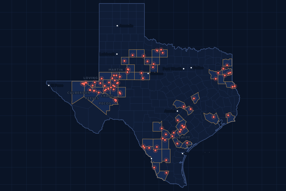
Counties and operators
Who drills, and where
Each county links to its Well Watch page, with its own map and every permit of the last two years. Each operator links to its page.
By county
- 1Midland County36
- 2Martin County17
- 3De Witt County16
- 4Culberson County12
- 5Webb County9
- 6Reeves County8
- 7Atascosa County7
- 8Ector County7
- 9Loving County7
- 10Reagan County7
- 11Pecos County6
- 12Ward County6
- 13Crane County5
- 14Scurry County4
- 15Shelby County4
And 37 more counties with fewer, in the list below.
By operator
- 1Endeavor Energy Resources L.P.18
- 2Diamondback E&P LLC15
- 3EOG Resources, Inc.15
- 4Burlington Resources O & G Co LP11
- 5Kinder Morgan Production Co LLC10
- 6XTO Energy Inc.9
- 7Cimarex Energy Co.7
- 8Continental Resources, Inc.7
- 9Ovintiv USA Inc.7
- 10Jetta Operating Company, Inc.6
- 11Pioneer Natural Res. USA, Inc.6
- 12SM Energy Company6
- 13Blackbeard Operating, LLC5
- 14Chevron U. S. A. Inc.5
- 15Cog Operating LLC5
And 49 more operators with fewer.
Register · July 8–14, 2024
Every permit, newest first
As the state files them: the lease and well, the operator, the kind of permit and the depth. “On the map” opens the county's live map at the well's spot.
Sunday, July 141 permit
- Crane CountyWaddell Tr A, well 4902HBlackbeard Operating, LLC · new drill · horizontal · 7,999 ftPermit 0900911 · API 42-103-37483On the map
Friday, July 1235 permits
- Atascosa CountyRoan K, well 10HEOG Resources, Inc. · new drill · horizontal · 9,000 ftPermit 0901133 · API 42-013-36184On the map
- Atascosa CountyRoan J, well 9HEOG Resources, Inc. · new drill · horizontal · 9,000 ftPermit 0901132 · API 42-013-36183On the map
- Atascosa CountyRoan H, well 8HEOG Resources, Inc. · new drill · horizontal · 9,000 ftPermit 0901131 · API 42-013-36182On the map
- Atascosa CountyRoan G, well 7HEOG Resources, Inc. · new drill · horizontal · 9,000 ftPermit 0901130 · API 42-013-36181On the map
- Atascosa CountyRoan F, well 6HEOG Resources, Inc. · new drill · horizontal · 9,000 ftPermit 0901129 · API 42-013-36179On the map
- Atascosa CountyRoan E, well 5HEOG Resources, Inc. · new drill · horizontal · 9,000 ftPermit 0901128 · API 42-013-36180On the map
- Culberson CountyLeonatus 11 Wr M, well 15HCimarex Energy Co. · new drill · horizontal · 15,000 ftPermit 0901176 · API 42-109-34289On the map
- Culberson CountyLeonatus 11 Wr L, well 14HCimarex Energy Co. · new drill · horizontal · 15,000 ftPermit 0901175 · API 42-109-34288On the map
- Culberson CountyLeonatus 11 Wr K, well 13HCimarex Energy Co. · new drill · horizontal · 15,000 ftPermit 0901173 · API 42-109-34287On the map
- Culberson CountyLeonatus 11 Wr J, well 12HCimarex Energy Co. · new drill · horizontal · 15,000 ftPermit 0901172 · API 42-109-34286On the map
- Culberson CountyHay Henley H, well 0024WCChevron U. S. A. Inc. · new drill · horizontal · 10,600 ftPermit 0901051 · API 42-109-34285On the map
- Culberson CountyHay Henley G, well 0023WCChevron U. S. A. Inc. · new drill · horizontal · 10,600 ftPermit 0901050 · API 42-109-34284On the map
- Culberson CountyHay Henley F, well 0022WCChevron U. S. A. Inc. · new drill · horizontal · 10,600 ftPermit 0901049 · API 42-109-34283On the map
- Culberson CountyHay Henley E, well 0021WCChevron U. S. A. Inc. · new drill · horizontal · 10,600 ftPermit 0901048 · API 42-109-34282On the map
- De Witt CountyChumchal-Martinez, well 1HSilverbow Resources Oper, LLC · new drill · horizontal · 14,000 ftPermit 0900983 · API 42-123-35452On the map
- Dickens CountyGina, well 1Halliburton Operating Company · new drill · vertical · 5,000 ftPermit 0901154 · API 42-125-31422On the map
- Dimmit CountySan Pedro Ranch, well 5710HGrit Oil & Gas Management, LLC · new drill · horizontal · 4,500 ftPermit 0901184 · API 42-127-38941On the map
- Duval CountyHelena, well 1Mantle Oil & Gas, LLC · new drill · vertical · 6,600 ftPermit 0901167 · API 42-131-39693On the map
- Harrison CountyBlocker Sus B, well 2HComstock Oil & Gas, LLC · new drill · horizontal · 15,000 ftPermit 0900608 · API 42-203-35682On the map
- Lee CountySpitzenberger Ef, well 2HSage Natural Resources LLC · new drill · horizontal · 8,500 ftPermit 0900915 · API 42-287-32791On the map
- Lee CountySpitzenberger Ef A, well 1HSage Natural Resources LLC · new drill · horizontal · 8,500 ftPermit 0900913 · API 42-287-32790On the map
- Loving CountyScott-State-Afterbuzz E, well 143HCivitas Permian Operating, LLC · new drill · horizontal · 11,000 ftPermit 0901164 · API 42-301-37040On the map
- Loving CountyScott-State-Afterbuzz C, well 112HCivitas Permian Operating, LLC · new drill · horizontal · 11,000 ftPermit 0901163 · API 42-301-37039On the map
- Loving CountyScott-State-Afterbuzz D, well 123HCivitas Permian Operating, LLC · new drill · horizontal · 12,000 ftPermit 0901162 · API 42-301-37038On the map
- Loving CountyScott-State-Afterbuzz B, well 142HCivitas Permian Operating, LLC · new drill · horizontal · 11,000 ftPermit 0901159 · API 42-301-37037On the map
- Martin CountyBrown SWD, well 1Overflow Energy Permian, LLC · recompletion · vertical · 5,000 ftPermit 0901137 · API 42-317-40809On the map
- Reeves CountyMasked Rider SWD, well 1Velocity Water Solutions, LP · new drill · vertical · 6,400 ftPermit 0901104 · API 42-389-41285On the map
- Robertson CountyPerry Gas Unit, well 2Hilcorp Energy Company · recompletion · vertical · 12,650 ftPermit 0901047 · API 42-395-31658On the map
- Scurry CountyLion Diamond 'M' Unit, well I 6BKinder Morgan Production Co LLC · new drill · vertical · 7,800 ftPermit 0901103 · API 42-415-35759On the map
- Scurry CountyLion Diamond 'M' Unit, well J 1BKinder Morgan Production Co LLC · new drill · vertical · 7,800 ftPermit 0901102 · API 42-415-35758On the map
- Shackelford CountyNail 110, well 1Bluff Creek Petroleum, LLC · new drill · vertical · 1,999 ftPermit 0901111 · API 42-417-39805On the map
- Upton CountyJudy Julibeth (Sa) O, well 1376WBSM Energy Company · new drill · horizontal · 10,400 ftPermit 0901161 · API 42-461-42882On the map
- Upton CountyJudy Julibeth (Sa) N, well 1375WBSM Energy Company · new drill · horizontal · 10,400 ftPermit 0901157 · API 42-461-42881On the map
- Webb CountyStanley Ranch, well 102HYJavelin Energy Partners Mgmt LLC · new drill · horizontal · 9,000 ftPermit 0901114 · API 42-479-45174On the map
- Winkler CountyB.f. Kennedy 23, well 1HBoyd & McWilliams Operating, LLC · new drill · horizontal · 8,100 ftPermit 0901125 · API 42-495-34994On the map
Thursday, July 1138 permits
- Archer CountyStaley-Mangold Unit, well 126Stephens & Johnson Operating Co. · recompletion · vertical · 4,076 ftPermit 0901112 · API 42-009-42783On the map
- Atascosa CountyFrank, well 2Pressly Oil Interest, Inc. · new drill · vertical · 500 ftPermit 0901106 · API 42-013-36178On the map
- Cass CountyGeronimo, well 1Fossil Petroleum LLC · new drill · vertical · 11,600 ftPermit 0901115 · API 42-067-30954On the map
- De Witt CountyChumchal Unit B, well 2HSilverbow Resources Oper, LLC · new drill · horizontal · 14,000 ftPermit 0900980 · API 42-123-35450On the map
- De Witt CountyStraube Unit A, well 11Burlington Resources O & G Co LP · new drill · horizontal · 17,500 ftPermit 0900820 · API 42-123-35448On the map
- De Witt CountyStraube Unit A, well 10Burlington Resources O & G Co LP · new drill · horizontal · 17,500 ftPermit 0900817 · API 42-123-35447On the map
- De Witt CountyStraube Unit A, well 9Burlington Resources O & G Co LP · new drill · horizontal · 17,500 ftPermit 0900816 · API 42-123-35446On the map
- Gregg CountyBernice Smith Marting Gas Unit, well 2Harleton Oil & Gas Inc. · recompletion · vertical · 11,900 ftPermit 0901045 · API 42-183-30877On the map
- Jefferson CountyBead Farm Company, well 4Exxonmobil Low C Sol on Stor LLC · new drill · vertical · 10,000 ftPermit 0901180 · API 42-245-32914On the map
- Loving CountyState-Judge 48-3 Bn Xxxv, well 35HCircle-S Energy, LLC · new drill · horizontal · 11,100 ftPermit 0900987 · API 42-301-37036On the map
- Loving CountyState-Judge 48-3 Bn Xxxiii, well 33HCircle-S Energy, LLC · new drill · horizontal · 11,100 ftPermit 0900985 · API 42-301-37035On the map
- Loving CountyState-Judge 48-3 Bn Xxxii, well 32HCircle-S Energy, LLC · new drill · horizontal · 11,100 ftPermit 0900984 · API 42-301-37033On the map
- McMullen CountyBobo A, well 1HGulftex Energy, LLC · new drill · horizontal · 10,500 ftPermit 0901064 · API 42-311-37534On the map
- Medina CountyRalph & Sons Farms, Inc., well 3Premier Minerals, Inc. · new drill · vertical · 1,500 ftPermit 0901136 · API 42-325-34378On the map
- Midland CountyQuinlyn 36B, well 6HDOvintiv USA Inc. · new drill · horizontal · 10,300 ftPermit 0901082 · API 42-329-47216On the map
- Midland CountyQuinlyn 36B, well 5HFOvintiv USA Inc. · new drill · horizontal · 10,300 ftPermit 0901080 · API 42-329-47215On the map
- Midland CountyQuinlyn 36B, well 4HLOvintiv USA Inc. · new drill · horizontal · 10,300 ftPermit 0901076 · API 42-329-47214On the map
- Midland CountyQuinlyn 36A, well 3HDOvintiv USA Inc. · new drill · horizontal · 10,300 ftPermit 0901075 · API 42-329-47213On the map
- Midland CountyQuinlyn 36A, well 2HFOvintiv USA Inc. · new drill · horizontal · 10,300 ftPermit 0901073 · API 42-329-47212On the map
- Midland CountyQuinlyn 36A, well 1HLOvintiv USA Inc. · new drill · horizontal · 10,300 ftPermit 0901072 · API 42-329-47189On the map
- Midland CountyWth 7-18 C, well 131Endeavor Energy Resources L.P. · new drill · horizontal · 8,658 ftPermit 0900364 · API 42-329-47100On the map
- Midland CountyWth 7-18 C, well 233Endeavor Energy Resources L.P. · new drill · horizontal · 8,658 ftPermit 0900283 · API 42-329-47089On the map
- Midland CountyWth 7-18 B1, well 223Endeavor Energy Resources L.P. · new drill · horizontal · 11,000 ftPermit 0900274 · API 42-329-47088On the map
- Midland CountyWth 7-18 B, well 122Endeavor Energy Resources L.P. · new drill · horizontal · 8,658 ftPermit 0900273 · API 42-329-47086On the map
- Midland CountyWth 7-18 A1, well 212Endeavor Energy Resources L.P. · new drill · horizontal · 11,000 ftPermit 0900272 · API 42-329-47085On the map
- Midland CountyWth 7-18 A, well 211Endeavor Energy Resources L.P. · new drill · horizontal · 8,658 ftPermit 0900271 · API 42-329-47084On the map
- Midland CountyWth 10-3 E, well 253Endeavor Energy Resources L.P. · new drill · horizontal · 11,000 ftPermit 0898343 · API 42-329-46896On the map
- Reagan CountyUniversity 09A, well 1005HPermian Resources Operating, LLC · recompletion · horizontal · 8,657 ftPermit 0901020 · API 42-383-38753On the map
- Shelby CountyJeannine D, well 4HHog Operating LLC · new drill · horizontal · 12,500 ftPermit 0900549 · API 42-419-31894On the map
- Shelby CountyJeannine C, well 3HApex Natural Gas, LLC · new drill · horizontal · 12,600 ftPermit 0900547 · API 42-419-31893On the map
- Shelby CountyJeannine B, well 2HApex Natural Gas, LLC · new drill · horizontal · 12,500 ftPermit 0900508 · API 42-419-31892On the map
- Starr CountyI.v. Montalvo 'A', well 20Killam Oil Co., Ltd. · recompletion · vertical · 5,526 ftPermit 0901123 · API 42-427-34762On the map
- Taylor CountyKissell, well 16WIL.c.s. Production Company · new drill · vertical · 4,999 ftPermit 0901179 · API 42-441-34703On the map
- Throckmorton CountyMatthews 23, well 4Subsea Operating Co. · new drill · vertical · 1,700 ftPermit 0901168 · API 42-447-36851On the map
- Upton CountyHensley 41E, well 1HLOvintiv USA Inc. · new drill · horizontal · 10,300 ftPermit 0900960 · API 42-461-42872On the map
- Webb CountyStanley Ranch, well 102HZJavelin Energy Partners Mgmt LLC · new drill · horizontal · 9,000 ftPermit 0901113 · API 42-479-45173On the map
- Webb CountyMb - Ocho - Lm A, well 112HEOG Resources, Inc. · new drill · horizontal · 14,000 ftPermit 0900927 · API 42-479-45166On the map
- Williamson CountyRieger, well 10North Texas Energy,inc. · new drill · vertical · 1,500 ftPermit 0901117 · API 42-491-30504On the map
Wednesday, July 1038 permits
- Andrews CountyRatliff & Bedford, well 46Occidental Permian Ltd. · recompletion · vertical · 9,200 ftPermit 0900628 · API 42-003-38631On the map
- Baylor CountyWaggoner Dn-West, well 2604DNW.t. Waggoner Estate, Inc. · new drill · vertical · 6,000 ftPermit 0901035 · API 42-023-31808On the map
- Bee CountyEvans Bros, well 3Welderxp Ltd. · new drill · vertical · 3,900 ftPermit 0900995 · API 42-025-34056On the map
- Caldwell CountySecretariat, well 1HMillennium Exploration Co. LLC · new drill · horizontal · 3,000 ftPermit 0901028 · API 42-055-35189On the map
- Crane CountyWaddell Tr A, well 4091HBlackbeard Operating, LLC · new drill · horizontal · 7,999 ftPermit 0900886 · API 42-103-37482On the map
- Crane CountyWaddell Tr 1, well 3893Blackbeard Operating, LLC · new drill · vertical · 10,250 ftPermit 0900858 · API 42-103-37485On the map
- Crane CountyWaddell Tr 1, well 3892Blackbeard Operating, LLC · new drill · vertical · 10,250 ftPermit 0900857 · API 42-103-37484On the map
- De Witt CountyBaros Krause Usw A, well 1Burlington Resources O & G Co LP · new drill · horizontal · 17,500 ftPermit 0901066 · API 42-123-35454On the map
- De Witt CountyBaros Unit A, well 7Burlington Resources O & G Co LP · new drill · horizontal · 17,500 ftPermit 0901063 · API 42-123-35453On the map
- De Witt CountyChumchal-Gerdes, well 1HSilverbow Resources Oper, LLC · new drill · horizontal · 14,000 ftPermit 0900981 · API 42-123-35451On the map
- De Witt CountyStraube Unit A, well 12Burlington Resources O & G Co LP · new drill · horizontal · 17,500 ftPermit 0900821 · API 42-123-35449On the map
- De Witt CountyStraube Unit A, well 8Burlington Resources O & G Co LP · new drill · horizontal · 17,500 ftPermit 0900812 · API 42-123-35445On the map
- De Witt CountyHoermann-Kolm B, well 3HSilverbow Resources Oper, LLC · new drill · horizontal · 16,000 ftPermit 0900761 · API 42-123-35443On the map
- De Witt CountyHoermann-Kolm A, well 2HSilverbow Resources Oper, LLC · new drill · horizontal · 16,000 ftPermit 0900760 · API 42-123-35442On the map
- De Witt CountyGunn-Weigelt Usw H, well 1Burlington Resources O & G Co LP · new drill · horizontal · 17,500 ftPermit 0900667 · API 42-123-35437On the map
- De Witt CountyAdix Unit A, well 9Burlington Resources O & G Co LP · new drill · horizontal · 17,500 ftPermit 0900664 · API 42-123-35441On the map
- De Witt CountyAdix Unit A, well 8Burlington Resources O & G Co LP · new drill · horizontal · 17,500 ftPermit 0900662 · API 42-123-35439On the map
- De Witt CountyGunn-Weigelt Usw F, well 1Burlington Resources O & G Co LP · new drill · horizontal · 17,500 ftPermit 0900651 · API 42-123-35436On the map
- Ector CountyHenderson-Penwell S SWD, well 2Ring Energy, Inc. · new drill · vertical · 11,500 ftPermit 0901166 · API 42-135-44059On the map
- Ector CountyHenderson-Penwell N SWD, well 1Ring Energy, Inc. · new drill · vertical · 11,500 ftPermit 0901165 · API 42-135-44058On the map
- Garza CountyPost-Montgomery Unit 1, well S 2BBrown, Geo. R Partnership,lp,the · reclass · vertical · 2,950 ftPermit 0900819 · API 42-169-02110On the map
- Garza CountyPost-Montgomery Unit 1, well S 1BBrown, Geo. R Partnership,lp,the · reclass · vertical · 2,939 ftPermit 0900818 · API 42-169-00804On the map
- Harris CountyR J S Unit, well 7WRD Operating LLC · recompletion · vertical · 8,365 ftPermit 0901056 · API 42-201-30797On the map
- Harrison CountyTrammell, well 2Brookston Energy, Inc. · recompletion · vertical · 9,800 ftPermit 0900097 · API 42-203-31071On the map
- Howard CountyS Wilkinson, well 141LLOxyrock Operating, LLC · new drill · horizontal · 9,000 ftPermit 0900957 · API 42-227-42536On the map
- Midland CountyTxl 33 Unit 2, well 4005BHXTO Energy Inc. · new drill · horizontal · 10,500 ftPermit 0901097 · API 42-329-47197On the map
- Midland CountyTxl 33 Unit 2, well 4075JHXTO Energy Inc. · new drill · horizontal · 10,500 ftPermit 0901096 · API 42-329-47196On the map
- Midland CountyTxl 33 Unit 2, well 4016AHXTO Energy Inc. · new drill · horizontal · 10,500 ftPermit 0901094 · API 42-329-47195On the map
- Midland CountyTxl 33 Unit 2, well 4007BHXTO Energy Inc. · new drill · horizontal · 10,500 ftPermit 0901093 · API 42-329-47194On the map
- Midland CountyTxl 33 Unit 2, well 4077JHXTO Energy Inc. · new drill · horizontal · 10,500 ftPermit 0901091 · API 42-329-47193On the map
- Midland CountyTxl 33 Unit 2, well 4018AHXTO Energy Inc. · new drill · horizontal · 10,500 ftPermit 0901090 · API 42-329-47192On the map
- Midland CountyTxl 33-27 Alloc, well 4009BHXTO Energy Inc. · new drill · horizontal · 10,500 ftPermit 0901089 · API 42-329-47191On the map
- Midland CountyTxl 33 Unit 2, well 4079JHXTO Energy Inc. · new drill · horizontal · 10,500 ftPermit 0901088 · API 42-329-47190On the map
- Reeves CountyOryx SWD, well 1Goodnight Midstream Permian, LLC · new drill · vertical · 4,900 ftPermit 0901158 · API 42-389-41286On the map
- Scurry CountyLion Diamond 'M' Unit, well K 7BKinder Morgan Production Co LLC · new drill · vertical · 7,800 ftPermit 0901100 · API 42-415-35757On the map
- Scurry CountyLion Diamond 'M' Unit, well E 13Kinder Morgan Production Co LLC · new drill · vertical · 7,800 ftPermit 0901099 · API 42-415-35756On the map
- Smith CountyOdom 'Tp' 15, well 15Faulconer Energy, LLC · recompletion · vertical · 12,380 ftPermit 0901026 · API 42-423-32179On the map
- Ward CountyBarstow -26-, well 8Jetta Operating Company, Inc. · new drill · vertical · 7,500 ftPermit 0900599 · API 42-475-38812On the map
Tuesday, July 932 permits
- Bee CountyEvans Bros, well 2Welderxp Ltd. · new drill · vertical · 3,900 ftPermit 0900994 · API 42-025-34055On the map
- Bee CountyEvans Bros, well 1Welderxp Ltd. · new drill · vertical · 3,900 ftPermit 0900993 · API 42-025-34054On the map
- Culberson CountyHay Denise State 08/05, well 0037WCChevron U. S. A. Inc. · new drill · horizontal · 12,000 ftPermit 0900921 · API 42-109-34271On the map
- Gonzales CountyDorothy Unit, well 13HEOG Resources, Inc. · new drill · horizontal · 11,000 ftPermit 0901019 · API 42-177-34717On the map
- Gonzales CountyDorothy Unit, well 12HEOG Resources, Inc. · new drill · horizontal · 11,000 ftPermit 0901017 · API 42-177-34716On the map
- Haskell CountyCahill, well 3Wilcox Petroleum Operating Llc. · new drill · vertical · 6,000 ftPermit 0900997 · API 42-207-33041On the map
- Howard CountySideoats E, well 5HACrownquest Operating, LLC · new drill · horizontal · 9,000 ftPermit 0901012 · API 42-227-42538On the map
- La Salle CountyHenderson-Cenizo Psa I, well 19HLewis Petro Properties, Inc. · new drill · horizontal · 12,250 ftPermit 0901079 · API 42-283-37705On the map
- La Salle CountyHenderson-Cenizo Psa H, well 18HLewis Petro Properties, Inc. · new drill · horizontal · 12,250 ftPermit 0901078 · API 42-283-37704On the map
- Midland CountyTex-Harvey Spraberry, well 781Endeavor Energy Resources L.P. · new drill · horizontal · 8,100 ftPermit 0900840 · API 42-329-47167On the map
- Midland CountyTex-Harvey Spraberry, well 761Endeavor Energy Resources L.P. · new drill · horizontal · 8,100 ftPermit 0900839 · API 42-329-47166On the map
- Midland CountyTex-Harvey Spraberry, well 751Endeavor Energy Resources L.P. · new drill · horizontal · 8,100 ftPermit 0900838 · API 42-329-47165On the map
- Midland CountyPatton 34-39 D, well 4MSDiamondback E&P LLC · new drill · horizontal · 13,000 ftPermit 0900571 · API 42-329-47117On the map
- Mitchell CountyAl Dunn, well 1Highpeak Energy Holdings, LLC · re-entry · vertical · 7,674 ftPermit 0900802 · API 42-335-00003On the map
- Nolan CountyElisa, well 1Scout Energy Management LLC · recompletion · vertical · 5,650 ftPermit 0901054 · API 42-353-33398On the map
- Pecos CountyYates Field Unit, well 49A41Kinder Morgan Production Co LLC · recompletion · horizontal · 1,999 ftPermit 0901043 · API 42-371-06117On the map
- Pecos CountyYates Field Unit, well 40C49Kinder Morgan Production Co LLC · recompletion · horizontal · 1,999 ftPermit 0901027 · API 42-371-33603On the map
- Pecos CountyYates Field Unit, well 214J41Kinder Morgan Production Co LLC · recompletion · horizontal · 1,999 ftPermit 0901011 · API 42-371-33613On the map
- Reeves CountyState Finkle Unit, well 711HEOG Resources, Inc. · new drill · horizontal · 14,000 ftPermit 0900641 · API 42-389-41284On the map
- Reeves CountyState Finkle Unit, well 731HEOG Resources, Inc. · new drill · horizontal · 14,000 ftPermit 0900640 · API 42-389-41283On the map
- Reeves CountyState Finkle Unit, well 751HEOG Resources, Inc. · new drill · horizontal · 14,000 ftPermit 0900639 · API 42-389-41282On the map
- Rusk CountyHelvenston SWD, well 1DSabine Oil & Gas Corporation · new drill · vertical · 8,350 ftPermit 0901087 · API 42-401-35485On the map
- Ward CountyWorsham -42-, well 50Jetta Operating Company, Inc. · new drill · vertical · 7,500 ftPermit 0901010 · API 42-475-38827On the map
- Ward CountyHunter, well 7Jetta Operating Company, Inc. · new drill · vertical · 7,500 ftPermit 0901009 · API 42-475-38828On the map
- Ward CountyWorsham -42-, well 49Jetta Operating Company, Inc. · new drill · vertical · 7,500 ftPermit 0901008 · API 42-475-38826On the map
- Ward CountyEdwards Deep Unit, well 7Jetta Operating Company, Inc. · new drill · vertical · 7,500 ftPermit 0901006 · API 42-475-38825On the map
- Ward CountyEdwards Deep Unit, well 6Jetta Operating Company, Inc. · new drill · vertical · 7,500 ftPermit 0901005 · API 42-475-38824On the map
- Webb CountySan Ambrosia D (SA16), well 3288HSM Energy Company · new drill · horizontal · 7,000 ftPermit 0901042 · API 42-479-45172On the map
- Webb CountySan Ambrosia D (SA15), well 3279HSM Energy Company · new drill · horizontal · 7,000 ftPermit 0901041 · API 42-479-45171On the map
- Webb CountySan Ambrosia D (SA14), well 3268HSM Energy Company · new drill · horizontal · 7,000 ftPermit 0901040 · API 42-479-45170On the map
- Webb CountySan Ambrosia D (SA13), well 3259HSM Energy Company · new drill · horizontal · 7,000 ftPermit 0901039 · API 42-479-45169On the map
- Zapata CountyTrevino, well 23Hilcorp Energy Company · recompletion · vertical · 9,600 ftPermit 0901029 · API 42-505-34862On the map
Monday, July 861 permits
- Archer CountyCowan Mckinney Unit, well 4LLMH Energy · new drill · vertical · 1,999 ftPermit 0900736 · API 42-009-43361On the map
- Archer CountyCowan-Mckinney Unit, well 3LLMH Energy · new drill · vertical · 1,999 ftPermit 0900735 · API 42-009-43360On the map
- Baylor CountyWaggoner Dntk, well 241DNW.t. Waggoner Estate, Inc. · new drill · vertical · 6,000 ftPermit 0900956 · API 42-023-31807On the map
- Crane CountyWaddell Tr C, well 3206Blackbeard Operating, LLC · recompletion · vertical · 6,130 ftPermit 0900892 · API 42-103-37057On the map
- Culberson CountyLookout 7 Fee Wr K, well 12HCimarex Energy Co. · new drill · horizontal · 15,000 ftPermit 0901001 · API 42-109-34281On the map
- Culberson CountyLookout 7 Fee Wr J, well 11HCimarex Energy Co. · new drill · horizontal · 15,000 ftPermit 0900999 · API 42-109-34280On the map
- Culberson CountyLookout 7 Fee Wr I, well 10HCimarex Energy Co. · new drill · horizontal · 15,000 ftPermit 0900998 · API 42-109-34279On the map
- Ector CountySchlemeyer South 4610D, well 04HContinental Resources, Inc. · new drill · horizontal · 12,000 ftPermit 0900837 · API 42-135-44057On the map
- Ector CountySchlemeyer South 4610C, well 03HContinental Resources, Inc. · new drill · horizontal · 12,000 ftPermit 0900835 · API 42-135-44056On the map
- Ector CountySchlemeyer South 4610B, well 02HContinental Resources, Inc. · new drill · horizontal · 12,000 ftPermit 0900834 · API 42-135-44055On the map
- Ector CountySchlemeyer North 3934D, well 04HContinental Resources, Inc. · new drill · horizontal · 12,000 ftPermit 0900831 · API 42-135-44054On the map
- Ector CountySchlemeyer North 3934C, well 03HContinental Resources, Inc. · new drill · horizontal · 12,000 ftPermit 0900830 · API 42-135-44053On the map
- Harrison CountyClower, well 1HRose City Resources, LLC · new drill · horizontal · 8,000 ftPermit 0900045 · API 42-203-35674On the map
- Howard CountySideoats E, well 4LLCrownquest Operating, LLC · new drill · horizontal · 9,000 ftPermit 0900996 · API 42-227-42537On the map
- Karnes CountyNapoo B, well 2HVerdun Oil & Gas LLC · new drill · horizontal · 11,360 ftPermit 0900976 · API 42-255-38103On the map
- Karnes CountyNapoo A, well 1HVerdun Oil & Gas LLC · new drill · horizontal · 11,343 ftPermit 0900975 · API 42-255-38102On the map
- Karnes CountyNueces A, well 1HEOG Resources, Inc. · new drill · horizontal · 11,500 ftPermit 0900169 · API 42-255-38096On the map
- King CountyQqq High River, well 4Sojourner Drilling Corporation · recompletion · vertical · 6,000 ftPermit 0900959 · API 42-269-31940On the map
- Martin CountyJohnson Ranch, well 411JHCog Operating LLC · new drill · horizontal · 12,000 ftPermit 0901018 · API 42-317-46276On the map
- Martin CountyJohnson Ranch, well 410SHCog Operating LLC · new drill · horizontal · 12,000 ftPermit 0901016 · API 42-317-46275On the map
- Martin CountyJohnson Ranch, well 410MHCog Operating LLC · new drill · horizontal · 12,000 ftPermit 0901015 · API 42-317-46274On the map
- Martin CountyJohnson Ranch, well 409AHCog Operating LLC · new drill · horizontal · 12,000 ftPermit 0901014 · API 42-317-46273On the map
- Martin CountyJohnson Ranch, well 408JHCog Operating LLC · new drill · horizontal · 12,000 ftPermit 0901013 · API 42-317-46272On the map
- Martin CountyMadeleine Faye 133-137 I, well 2USDiamondback E&P LLC · new drill · horizontal · 9,500 ftPermit 0900144 · API 42-317-46199On the map
- Martin CountyMadeleine Faye 133-137 G, well 2WBDiamondback E&P LLC · new drill · horizontal · 10,157 ftPermit 0900143 · API 42-317-46198On the map
- Martin CountyMadeleine Faye 133-137 K, well 2WDDiamondback E&P LLC · new drill · horizontal · 10,157 ftPermit 0900142 · API 42-317-46197On the map
- Martin CountyMadeleine Faye 133-137 J, well 1WDDiamondback E&P LLC · new drill · horizontal · 10,157 ftPermit 0900141 · API 42-317-46196On the map
- Martin CountyMadeleine Faye 133-137 D, well 1WBDiamondback E&P LLC · new drill · horizontal · 10,157 ftPermit 0900140 · API 42-317-46195On the map
- Martin CountyMadeleine Faye 133-137 H, well 1USDiamondback E&P LLC · new drill · horizontal · 9,500 ftPermit 0900139 · API 42-317-46194On the map
- Martin CountyMadeleine Faye 133-137 F, well 1MSDiamondback E&P LLC · new drill · horizontal · 9,500 ftPermit 0900138 · API 42-317-46193On the map
- Martin CountyMadeleine Faye 133-137 E, well 3LSDiamondback E&P LLC · new drill · horizontal · 9,500 ftPermit 0900137 · API 42-317-46192On the map
- Martin CountyMadeleine Faye 133-137 C, well 2LSDiamondback E&P LLC · new drill · horizontal · 9,500 ftPermit 0900136 · API 42-317-46191On the map
- Martin CountyMadeleine Faye 133-137 B, well 2JMDiamondback E&P LLC · new drill · horizontal · 9,500 ftPermit 0900135 · API 42-317-46190On the map
- Martin CountyMadeleine Faye 133-137 A, well 1LSDiamondback E&P LLC · new drill · horizontal · 9,500 ftPermit 0900134 · API 42-317-46189On the map
- Midland CountyWth 7-18 H1, well 282Endeavor Energy Resources L.P. · new drill · horizontal · 11,000 ftPermit 0900973 · API 42-329-47183On the map
- Midland CountyWth 7-18 H, well 284Endeavor Energy Resources L.P. · new drill · horizontal · 11,000 ftPermit 0900972 · API 42-329-47182On the map
- Midland CountyWth 7-18 H, well 283Endeavor Energy Resources L.P. · new drill · horizontal · 11,000 ftPermit 0900955 · API 42-329-47178On the map
- Midland CountyWth 7-18 H, well 171Diamondback E&P LLC · new drill · horizontal · 11,000 ftPermit 0900954 · API 42-329-47175On the map
- Midland CountyWth 7-18 G, well 272Endeavor Energy Resources L.P. · new drill · horizontal · 11,000 ftPermit 0900953 · API 42-329-47174On the map
- Midland CountyWth 7-18 F, well 265Endeavor Energy Resources L.P. · new drill · horizontal · 11,000 ftPermit 0900951 · API 42-329-47173On the map
- Midland CountyWth 7-18 F, well 264Endeavor Energy Resources L.P. · new drill · horizontal · 11,000 ftPermit 0900950 · API 42-329-47172On the map
- Midland CountyWth 7-18 F, well 163Endeavor Energy Resources L.P. · new drill · horizontal · 11,000 ftPermit 0900948 · API 42-329-47171On the map
- Midland CountyWth 7-18 F, well 162Endeavor Energy Resources L.P. · new drill · horizontal · 11,000 ftPermit 0900945 · API 42-329-47170On the map
- Midland CountyPatton 34-39 C, well 5WADiamondback E&P LLC · new drill · horizontal · 13,000 ftPermit 0900574 · API 42-329-47119On the map
- Midland CountyPatton 34-39 C, well 2JMDiamondback E&P LLC · new drill · horizontal · 13,000 ftPermit 0900573 · API 42-329-47120On the map
- Pecos CountyYates Field Unit, well 284A11Kinder Morgan Production Co LLC · recompletion · horizontal · 1,999 ftPermit 0900991 · API 42-371-34454On the map
- Pecos CountyYates Field Unit, well 214B76Kinder Morgan Production Co LLC · recompletion · horizontal · 1,999 ftPermit 0900982 · API 42-371-34683On the map
- Pecos CountyYates Field Unit, well 214ZA1Kinder Morgan Production Co LLC · recompletion · horizontal · 1,999 ftPermit 0900978 · API 42-371-35446On the map
- Reagan CountyTurner E2-1202F, well 106HPioneer Natural Res. USA, Inc. · new drill · horizontal · 10,291 ftPermit 0900190 · API 42-383-41799On the map
- Reagan CountyTurner E2-1202E, well 105HPioneer Natural Res. USA, Inc. · new drill · horizontal · 10,291 ftPermit 0900189 · API 42-383-41798On the map
- Reagan CountyTurner E2-1202D, well 104HPioneer Natural Res. USA, Inc. · new drill · horizontal · 10,291 ftPermit 0900188 · API 42-383-41797On the map
- Reagan CountyTurner E2-1202C, well 103HPioneer Natural Res. USA, Inc. · new drill · horizontal · 10,291 ftPermit 0900187 · API 42-383-41796On the map
- Reagan CountyTurner E2-1202B, well 102HPioneer Natural Res. USA, Inc. · new drill · horizontal · 10,291 ftPermit 0900186 · API 42-383-41795On the map
- Reagan CountyTurner E2-1202A, well 101HPioneer Natural Res. USA, Inc. · new drill · horizontal · 10,291 ftPermit 0900185 · API 42-383-41794On the map
- Reeves CountyRio Lobo State F, well 313HPermian Resources Operating, LLC · new drill · horizontal · 11,000 ftPermit 0900716 · API 42-389-41280On the map
- Reeves CountyLegacy 2623A-C3, well 5HContinental Resources, Inc. · new drill · horizontal · 12,200 ftPermit 0900223 · API 42-389-41250On the map
- Reeves CountyLegacy 2623A-C3, well 4HContinental Resources, Inc. · new drill · horizontal · 12,200 ftPermit 0900222 · API 42-389-41249On the map
- Refugio CountyWilliams, Maude Etal -A-, well D241HHilcorp Energy Company · new drill · horizontal · 6,500 ftPermit 0900971 · API 42-391-33337On the map
- Shelby CountyTiber, well 2BXTO Energy Inc. · new drill · horizontal · 20,000 ftPermit 0900286 · API 42-419-31842On the map
- Webb CountyCox - Mb - Martin B, well 111HEOG Resources, Inc. · new drill · horizontal · 13,250 ftPermit 0900897 · API 42-479-45163On the map
- Webb CountyCox - Mb - Martin A, well 110HEOG Resources, Inc. · new drill · horizontal · 13,250 ftPermit 0900896 · API 42-479-45162On the map
Cancelled permits are left out. To look a permit up at the source, use the Railroad Commission's drilling permit query with its permit number.
Archive
Earlier weeks
Each finished week, Monday to Sunday, has its own page that does not change. The feed gets one entry per week.
- Nov 9–15, 2026103
- Nov 2–8, 2026164
- Oct 26 – Nov 1, 2026242
- Oct 19–25, 2026215
- Oct 12–18, 2026147
- Oct 5–11, 2026166
- Sep 28 – Oct 4, 2026156
- Sep 21–27, 2026194
- Sep 14–20, 2026167
- Sep 7–13, 2026133
- Aug 31 – Sep 6, 2026182
- Aug 24–30, 2026118
Every week since January 1, 2024 (150 weeks)
2026
- Aug 17–23167
- Aug 10–16198
- Aug 3–9186
- Jul 27 – Aug 2143
- Jul 20–26170
- Jul 13–19117
- Jul 6–12194
- Jun 29 – Jul 5114
- Jun 22–28175
- Jun 15–21186
- Jun 8–14187
- Jun 1–7154
- May 25–31158
- May 18–24197
- May 11–17182
- May 4–10190
- Apr 27 – May 3156
- Apr 20–26210
- Apr 13–19133
- Apr 6–12206
- Mar 30 – Apr 5129
- Mar 23–29159
- Mar 16–22167
- Mar 9–15166
- Mar 2–8140
- Feb 23 – Mar 1181
- Feb 16–22141
- Feb 9–15133
- Feb 2–8124
- Jan 26 – Feb 1126
- Jan 19–25189
- Jan 12–18280
- Jan 5–11129
2025
- Dec 29 – Jan 4, 202656
- Dec 22–2846
- Dec 15–21154
- Dec 8–14119
- Dec 1–7128
- Nov 24–3061
- Nov 17–23140
- Nov 10–1698
- Nov 3–9107
- Oct 27 – Nov 2137
- Oct 20–26145
- Oct 13–19173
- Oct 6–12206
- Sep 29 – Oct 5124
- Sep 22–28141
- Sep 15–21165
- Sep 8–14127
- Sep 1–7105
- Aug 25–31145
- Aug 18–24115
- Aug 11–17140
- Aug 4–10131
- Jul 28 – Aug 3134
- Jul 21–27151
- Jul 14–20151
- Jul 7–13148
- Jun 30 – Jul 6148
- Jun 23–29167
- Jun 16–22118
- Jun 9–15115
- Jun 2–8147
- May 26 – Jun 190
- May 19–25148
- May 12–18120
- May 5–11114
- Apr 28 – May 4135
- Apr 21–27182
- Apr 14–20115
- Apr 7–13197
- Mar 31 – Apr 6194
- Mar 24–30170
- Mar 17–23189
- Mar 10–16177
- Mar 3–9141
- Feb 24 – Mar 2172
- Feb 17–23145
- Feb 10–16170
- Feb 3–9167
- Jan 27 – Feb 2149
- Jan 20–26158
- Jan 13–19176
- Jan 6–12140
2024
- Dec 30 – Jan 5, 202597
- Dec 23–295
- Dec 16–22168
- Dec 9–15202
- Dec 2–8182
- Nov 25 – Dec 189
- Nov 18–24189
- Nov 11–17145
- Nov 4–10152
- Oct 28 – Nov 3134
- Oct 21–27163
- Oct 14–20147
- Oct 7–13114
- Sep 30 – Oct 6138
- Sep 23–29133
- Sep 16–22175
- Sep 9–15144
- Sep 2–8138
- Aug 26 – Sep 1177
- Aug 19–25207
- Aug 12–18186
- Aug 5–11145
- Jul 29 – Aug 4191
- Jul 22–28174
- Jul 15–21164
- Jul 8–14205
- Jul 1–7106
- Jun 24–30183
- Jun 17–23192
- Jun 10–16161
- Jun 3–9176
- May 27 – Jun 2135
- May 20–26223
- May 13–19169
- May 6–12155
- Apr 29 – May 5191
- Apr 22–28224
- Apr 15–21200
- Apr 8–14157
- Apr 1–7149
- Mar 25–31102
- Mar 18–24130
- Mar 11–17228
- Mar 4–10178
- Feb 26 – Mar 3187
- Feb 19–25164
- Feb 12–18190
- Feb 5–11137
- Jan 29 – Feb 4177
- Jan 22–28172
- Jan 15–21107
- Jan 8–14251
- Jan 1–7148
FAQ
Questions people ask
What is a drilling permit?
Permission from the Railroad Commission of Texas to drill a well, or to re-enter or deepen an old one, at a stated spot and to a stated depth. An operator files for it before the rig comes; it lasts two years. Many permitted wells are drilled within months, some never are.
Is this week complete?
Yes. The state has issued permits on later days, so this week's list is closed. A permit the state cancels later drops off the list.
Some permits are not on the map. Why?
The map draws a permit at the well's surface location as the state files it. A new permit's location can take a few days to reach the state's files; until then it is listed here but not drawn.
Does a new permit near my land mean I will be paid?
No. A permit says where a well may be drilled, not whose minerals it will produce or who is paid. That depends on your lease, the unit the well is pooled in and the division order. If a well is drilled on or next to your tract, watch for a division order from the operator.
Can I get these by email or in a feed?
Yes. The feed on this page has one entry for each finished week, for any feed reader. For one county, an abstract or a lease, Texas Well Watch sends one email a week when the state files something new there; it is free with an account.
Sources
- Railroad Commission of Texas, drilling permit master and trailer, daily file (with latitudes and longitudes)www.rrc.texas.gov/resource-center/research/data-sets-available-for-download/ · loaded every night; newest permit on file November 19, 2026
- Railroad Commission of Texas, drilling permit query (one permit at the source)webapps.rrc.texas.gov/DP/initializePublicQueryAction.do · linked, not read
- US Census Bureau, cartographic boundary files (county lines), through the us-atlas package 3.0.1www.census.gov/geographies/mapping-files/time-series/geo/cartographic-boundary.html · built into the site with its well maps
- GeoNames, towns and their points (CC BY 4.0)www.geonames.org/ · built into the site with its town pages